

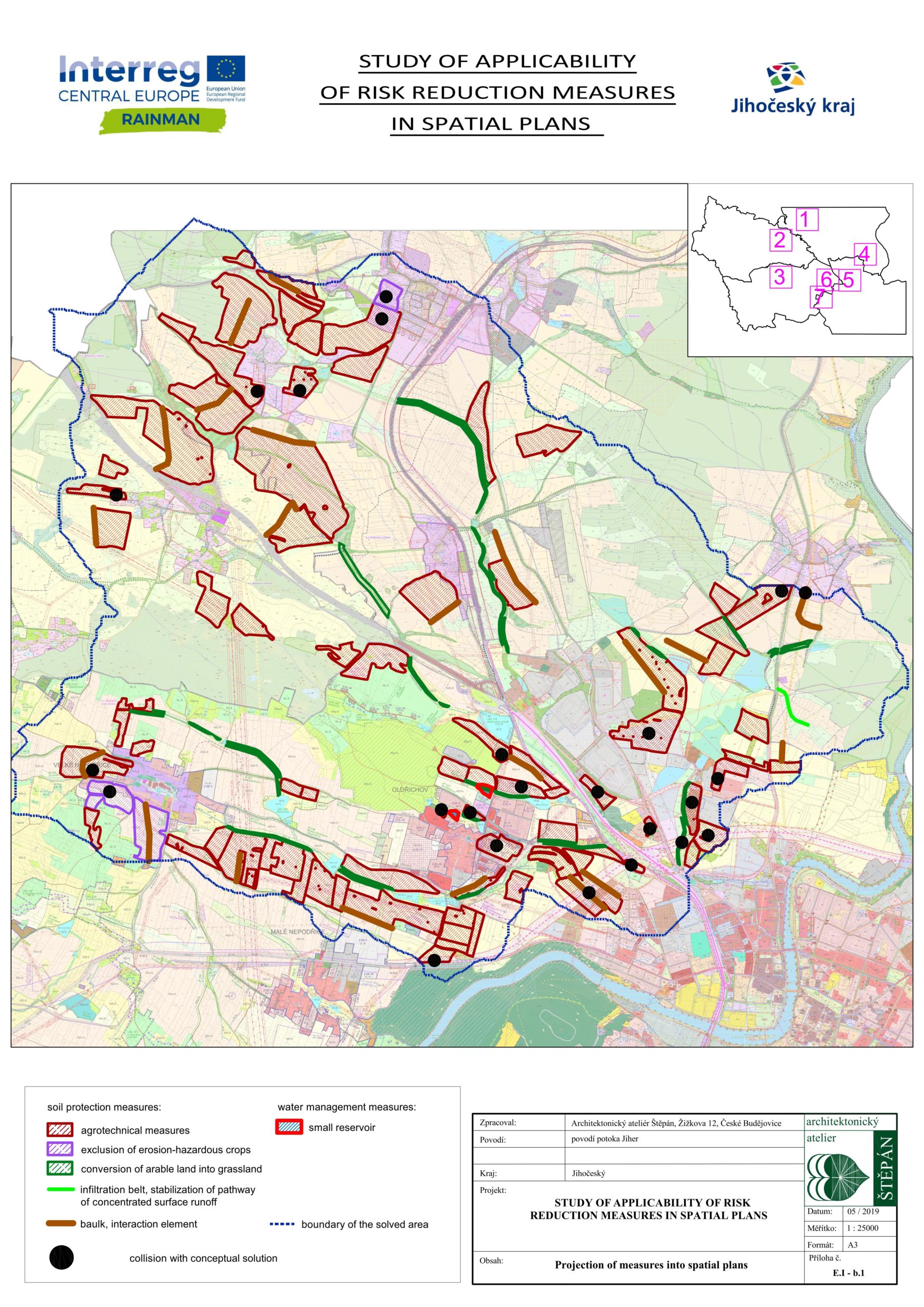
The South Bohemian Region in close cooperation with the Research Institute of Water Management T. G. Masaryk, v.v.i. (VÚV) and with an external contractor Štěpán Architectural Office prepared as their main output of project RAINMAN the “Study of applicability of risk reduction measures in spatial plans”. This study verifies the possibility of implementation of risk reduction measures designed to eliminate damages caused by torrential rains (pluvial floods), especially in built-up areas into municipal spatial planning documentation in pilot locations. The study is based on field research conducted at pilot sites (always consisting of one compact small river basin) and also on local knowledge in relation to torrential rainfalls identified mainly through meetings with municipal representatives (usually mayors). The result of the study is mainly proposals for changes to spatial plans, as the introduction of risk reduction measures directly into spatial planning documentation is an important step towards their implementation. At the same time, the study tests the possibility and suitability of using jointly developed RAINMAN methods and tools.
In conclusion, the municipalities welcomed the “Study of applicability of risk reduction measures in spatial plans”, as it provides them a comprehensive proposal for flood protection solutions for one coherent river basin. However, the fundamental problem for the implementation of risk reduction measures is for the municipalities to secure finances and resolve property relations.
The most important documents for the Czech part of the project can be downloaded here.
A webpage dedicated to the issue of implementing risk reduction measures into spatial plans in the Czech legal environment here.The locality is situated in South Bohemia, in the region Jindřichohradecko.
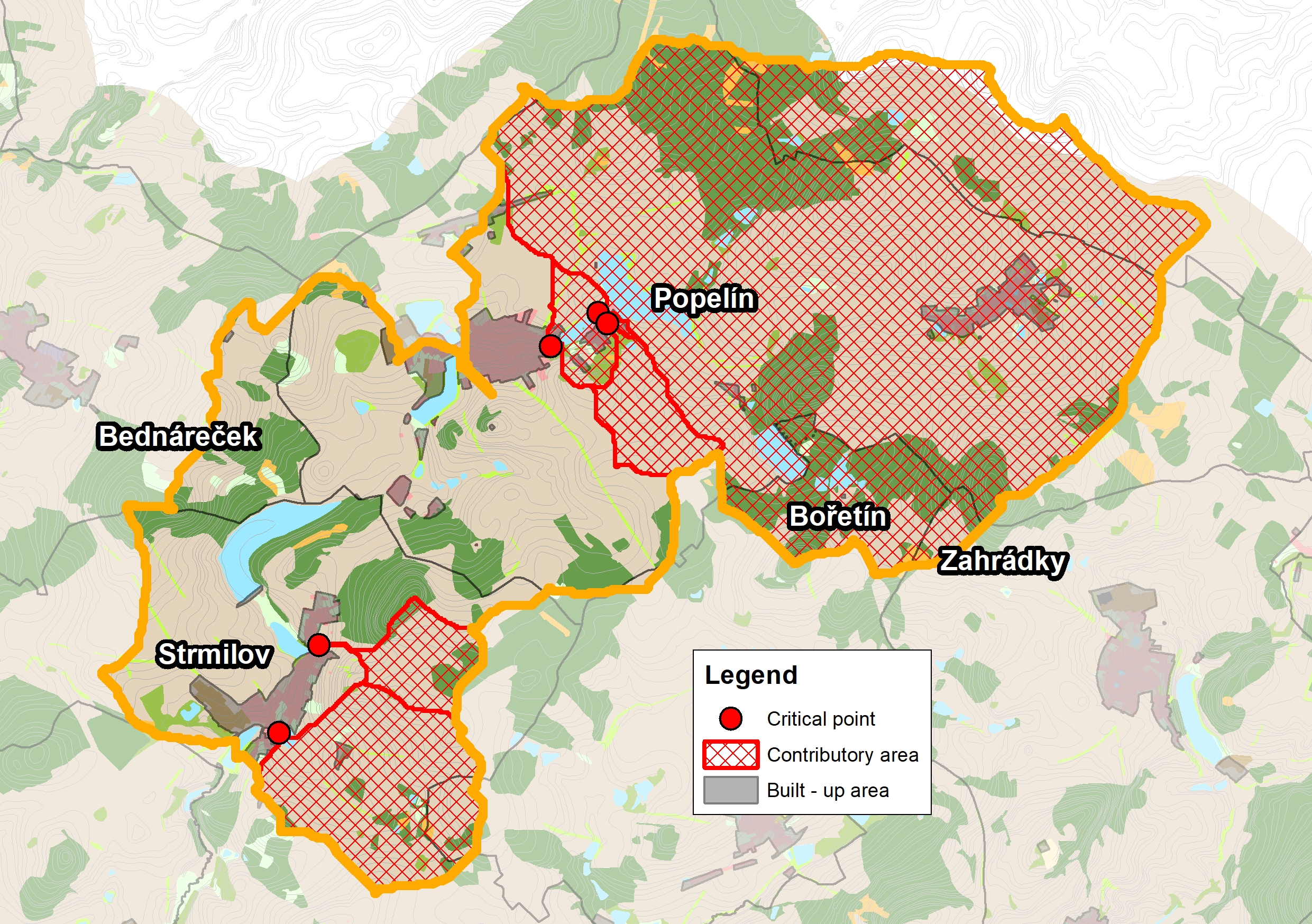
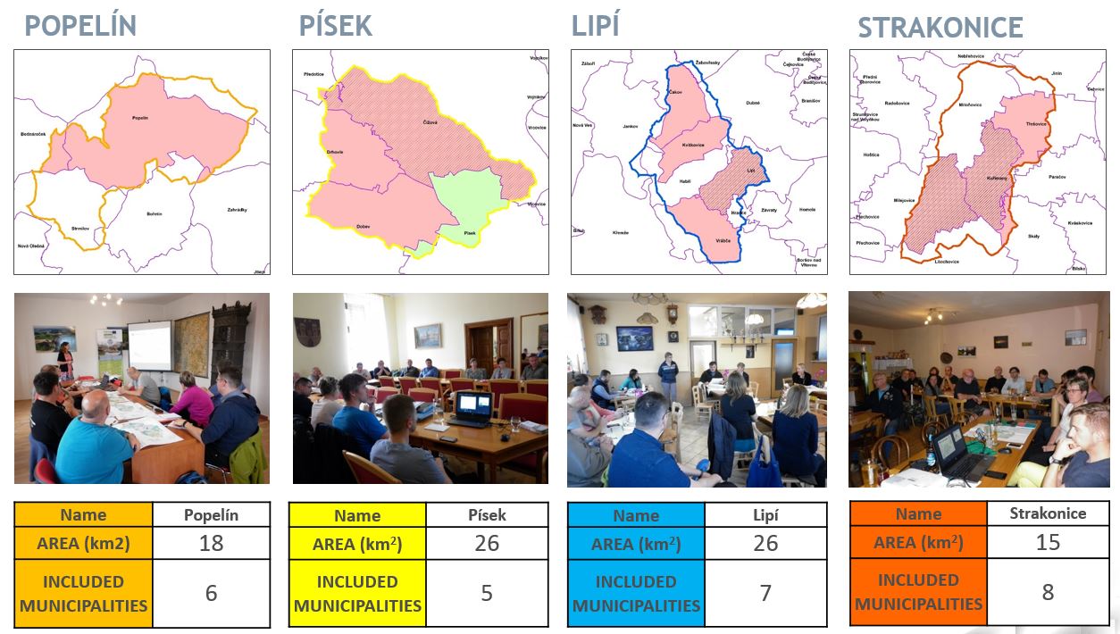
This locality includes the territory of six municipalities – Popelín, Strmilov, Bednáreček, Bořetín, Nová Olešná, Zahrádky. The pilot site does not include the whole administrative territories of all the named municipalities, but only those that together belong to one compact small basin of the Olešná brook.
The area of territory: 18 km2
Pilot type – this location is agricultural and semi-urban. Predominant type of land use in this location are agricultural areas (especially fields and meadows) and forests (predominantly coniferous forests). There are a lot of breeding ponds in this location.
Land form – this location is hilly.
It is specific for the locality that it is an area of historically established settlement. The axis of this settlement is a watercourse supplemented by a cascade (system) of bypass ponds. The valley of the Olešná brook passes through the built-up area of the villages of Popelín and the local parts of Horní Olešná and Česká Olešná.
M unicipalities in the locality have real experience with pluvial floods and they were struggling with the consequences of the heavy rain events. It was particularly the case of erosive soil damage and its carry-over to built-up areas of municipalities.
To eliminate the impacts of torrential rainfall, municipalities managed to change the way of management on soils susceptible to erosion in agreement with agricultural land managers. Due to the appropriate management of agricultural land, the erosion in this area has decreased significantly and essentially clear rainwater flows from the fields after torrential rains, which is drained from the municipalities in existing ditches or in the event of heavy rainfall on the roads.
 To achieve the maximum elimination of the negative impacts of floods caused by torrential rainfall, especially on built-up areas of municipalities, a comprehensive assessment of the entire catchment area into which the rainfall will fall is necessary. This principle is the cornerstone of the “Study of applicability of risk reduction measures in spatial plans”, in which one of the pilot sites is the Popelín site.
There are 5 so-called critical points in the locality Popelín, which are places where the consequences of torrential rainfall enter the built-up areas of municipalities and start to cause property damage. The aim of the “Study of applicability of risk reduction measures in spatial plans” in the Popelín locality is to propose such measures so that the so-called critical points disappear from the territory (ie the consequences of torrential rainfall would be fully captured before entering the built-up areas of municipalities) or at least the consequences of torrential rainfall in built-up areas would be minimized.
Based on the knowledge of local conditions (own research and consultations with the mayors of the municipality), risk reduction measures are proposed for the whole locality with the aim of mitigating the negative impact of torrential rainfall especially on built-up areas of municipalities. In particular, measures are proposed in this locality to eliminate erosive susceptible crops, to support conversion of arable land into grassland or to build up baulks, furrows or infiltration belts in the open countryside.
The proposed risk reduction 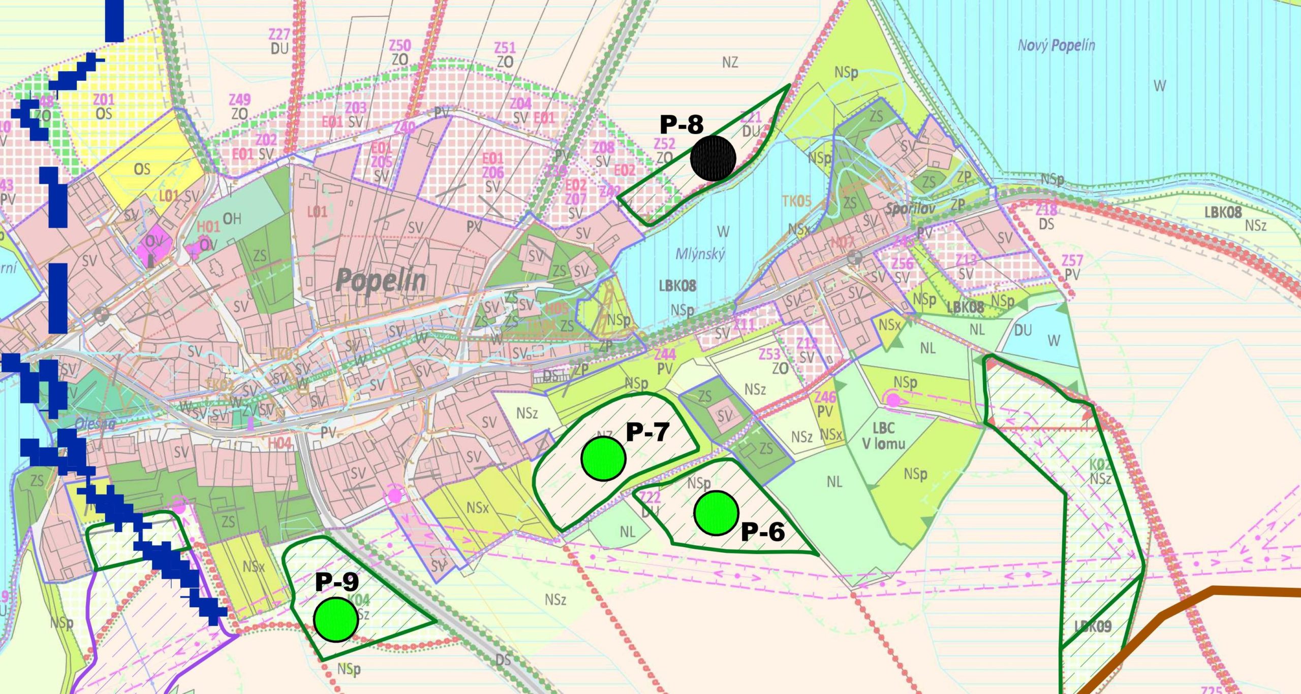 measures are then confronted with the spatial planning documentation of individual municipalities in the locality Popelín in the “Study of applicability of risk reduction measures in spatial plans”. From this confrontation it was concluded that none of the proposed measures is directly defined in the valid spatial planning documentation of individual municipality, however most of them do not interfere with any conceptual solution contained in spatial planning documentation of municipalities and could be placed (implemented) without change of spatial planning documentation. Only two measures conclude that they can influence the conception set in the spatial planning documentation. Both these “collision” places are located in the administrative area of Popelín. The first is the proposal of two water reservoirs in the cadastral area of Horní Olešná. Although the proposal of reservoirs does not interfere with any specific proposal of, for example, areas to be built, their location could be essential for the conception of the landscape arrangement here. The second “collision” point is the proposal of protective grassing, which partially extends to the Z08 area to be built using the “mixed residential-rural area” intended to be built mainly by the residential function, Z21 area to be built using the “transport infrastructure area” (this area is also included among the publicly beneficial buildings) and Z52 area with the use of “green areas – protective and insulating”.
For the Popelín locality it can be stated that the proposed measures are suitable for the protection of the current state of the territory. However, for coordination with the proposals contained in the spatial plans of individual municipalities, it would be necessary to examine how to modify the proposed measure to take into account and protect the future assumed state of the territory. However, the “Study of applicability of risk reduction measures in spatial plans” in this locality did not go into this detail; nevertheless, a detailed comprehensive solution up to the form of individual changes in spatial plans can be seen at the Lipí site.
More detailed information about this locality can be found in the study (here) or it is possible to see specific proposal measure from this locality “design of water reservoirs in Horní Olešná” prepared as an example of good practice (here).


- All
- Assessment and mapping
- Risk communication
- Risk reduction measures

Design of water reservoirs in Horní Olešná
– Pilot area Popelín
Read more in English [pdf, 488 KB]
Trainings on implementing the developed tools
– within the pilot regions in South Bohemia
Read more in English [pdf, 297 KB]

Critical points analysis
– for South Bohemia, CZ
Read more in English [pdf, 227 KB]
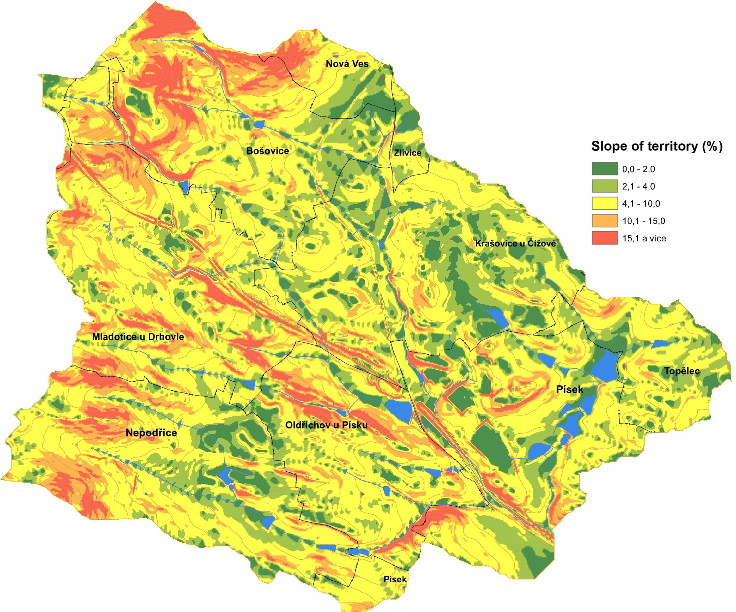
The locality is situated in South Bohemia, in the region Písecko.
This locality includes the territory of five municipalities – Čížová, Dobev, Drhovle, Písek and Předotice. The pilot site does not include the whole administrative territories of all the named municipalities, but only those that together belong to one compact small basin of the Jiher brook.
The area of territory: 26 km2
Pilot type – this location is mainly agricultural sub-urban, partly industrial too. Areas in this location are mainly used for agriculture (especially fields and partly meadows). Forests (predominantly coniferous) are here representated in relatively little rate. There are many breeding ponds in this location – especially in south-eastern part. In contrast to agricultural land use, an industrial zone is located in the immediate vicinity of the town of Písek.
Land form – this location is moderately hilly – rolling lands.
The locality is situated very close to the town Písek. The town Písek has a job potential and good transport accessibility. It is therefore specific for the locality that it includes the suburban zone of the town Písek intensively used for housing as well as industry and municipalities, which have considerable potential for the development of built-up areas for housing or mixed functions.
Other specifics are:
- territory is considerably divided by eight tributaries of the broom Jiher and significant line engineering structures and their corridors in radial arrangement to the city center,
- there are extensive coupled agricultural land (fields) in the territory – in the area 1000-1200 ha (the area of the pilot locality is 2600 ha.)
Municipalities in the locality have real experience with pluvial floods and they were struggling with the consequences of the heavy rain event. After heavy rains in 2013, two brooks (Mehelnický and Jiher) spilled over the banks. Hradištská and Ostrovní streets in Písek were flooded by Mehelnický brook. Where the Jiher brook broke out of the riverbed, the blocks of flats in the housing estate Portyč were flooded.
In response to the heavy rainfall of 2013, the municipal authority in Písek plans to take appropriate steps to improve flood prevention. It is considered to build a system of ponds and dry polders to provide protection in the event of increased water flow in the Mehelnický and Jiher brooks.
Also other municipalities in this location try to deal with flood protection eliminating the impacts of pluvial floods, but it is more about implementing individual measures, such as the reconstruction of the forest road in Topělec (near Čížová).

 To achieve the maximum elimination of the negative impacts of floods caused by torrential rainfall, especially on built-up areas of municipalities, a comprehensive assessment of the entire catchment area into which the rainfall will fall is necessary. This principle is the cornerstone of the “Study of applicability of risk reduction measures in spatial plans”, in which one of the pilot sites is the Písek site.
There are 3 so-called critical points in the locality Písek, which are places where the consequences of torrential rainfall enter the built-up areas of municipalities and start to cause property damage. The aim of the “Study of applicability of risk reduction measures in spatial plans” in the Písek locality is to propose such measures so that the so-called critical points disappear from the territory (ie the consequences of torrential rainfall would be fully captured before entering the built-up areas of 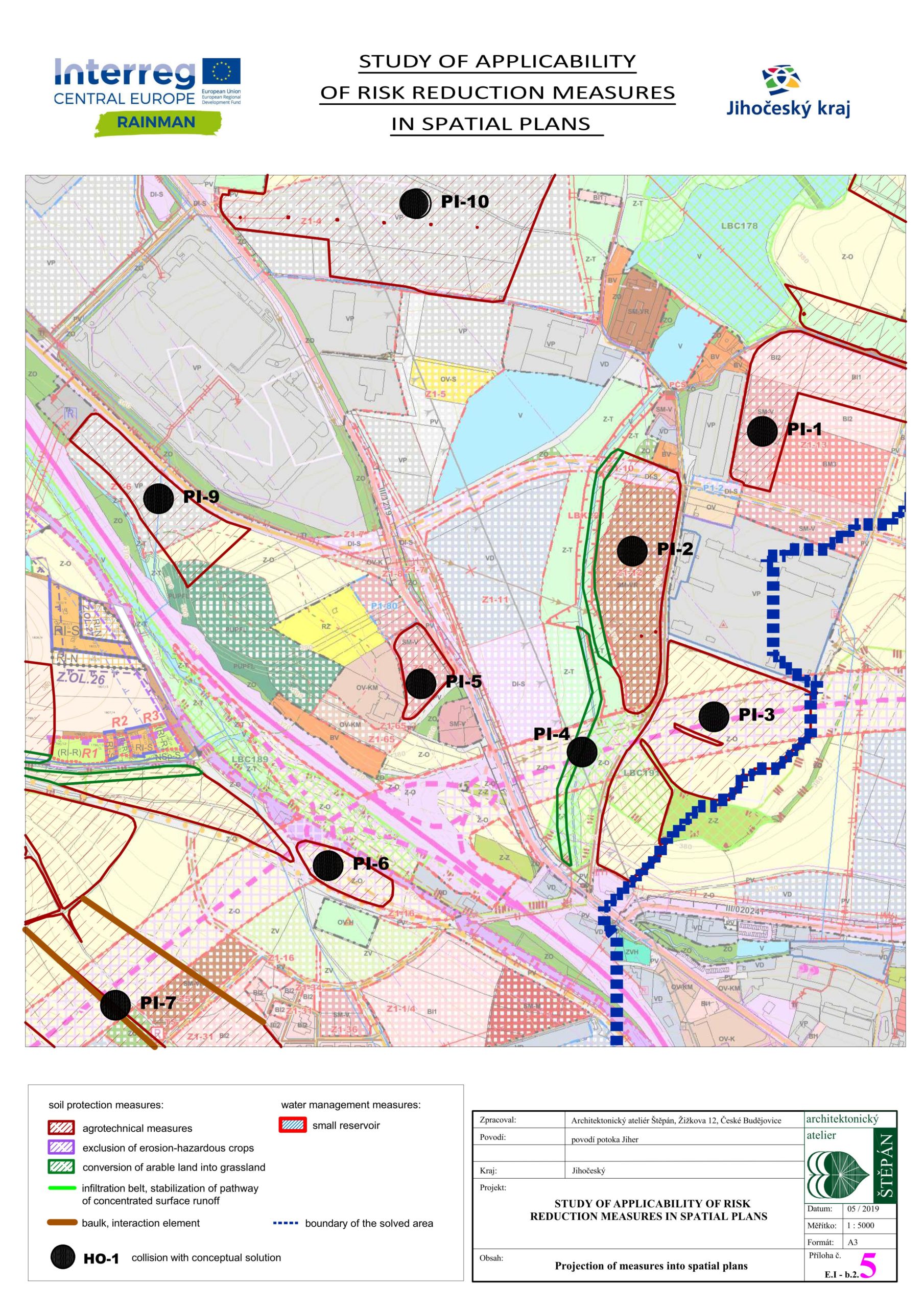 municipalities) or at least the consequences of torrential rainfall in built-up areas would be minimized.
Based on the knowledge of local conditions (own research and consultations with the mayors of the municipality), risk reduction measures are proposed for the whole locality with the aim of mitigating the negative impact of torrential rainfall especially on built-up areas of municipalities. In particular, measures are proposed in this locality to eliminate erosive susceptible crops, to support conversion of arable land into grassland or to build up baulks or infiltration belts in the open countryside.
The proposed risk reduction measures are then confronted with the spatial planning documentation of individual municipalities in the locality Písek in the “Study of applicability of risk reduction measures in spatial plans”. From this confrontation it was concluded that none of the proposed measures is directly defined in the valid spatial planning documentation of individual municipality. Although most of the protective measures are designed in the open landscape (in the undeveloped area of municipalities), it has been assessed at all sites that the concept of the land use plan may be affected, in a total of 24 cases. This is due to the fact that the municipalities in this locality have considerable development potential because they are located in close proximity to the town of Písek. The spatial plans of these municipalities therefore propose a significant number of new built-up areas in the area, which is currently undeveloped. Consequently, there is a conflict between the proposed measures and the proposed built-up areas.
For the Písek locality it can be stated that the proposed measures are suitable for the protection of the current state of the territory. However, for coordination with the proposals contained in the spatial plans of individual municipalities, it would be necessary to examine how to modify the proposed measure to take into account and protect the future assumed state of the territory. However, the “Study of applicability of risk reduction measures in spatial plans” in this locality did not go into this detail; nevertheless, a detailed comprehensive solution up to the form of individual changes in spatial plans can be seen at the Lipí site.
More detailed information about this locality can be found in the study (here) or it is possible to see specific proposal measure from this locality “Proposal of the interaction element – Baulk near Drhovle” prepared as an example of good practice (here).


- All
- Assessment and mapping
- Risk communication
- Risk reduction measures
Proposal of the interaction element – Baulk near Drhovle
– Pilot area Písek
Read more in English [pdf, 288 KB]
Trainings on implementing the developed tools
– within the pilot regions in South Bohemia
Read more in English [pdf, 297 KB]
Critical points analysis
– for South Bohemia, CZ
Read more in English [pdf, 227 KB]
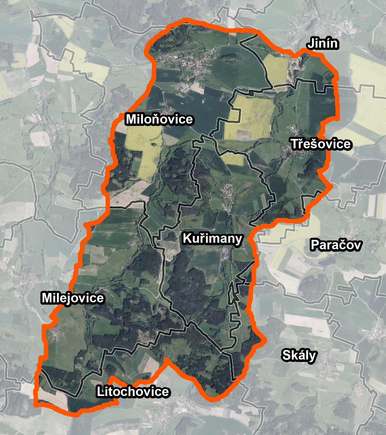
The locality is situated in South Bohemia, in the region Strakonicko.
This locality includes the territory of eight municipalities – Jinín, Kuřimany, Litochovice, Milejovice, Miloňovice, Paračov, Skály and Třešovice. The pilot site does not include the whole administrative territories of all the named municipalities, but only those that together belong to one compact small basin of the Zborkovický brook.
The area of territory: 15 km2
Pilot type – this location is agricultural and semi-urban. Areas in this location are mainly used for agriculture (fields and meadows). Agricultural land is mostly integrated into large soil blocks and is on slightly sloping land. Forests are concentrated mainly in the southern half of this location.
Land form – this location is moderately hilly – rolling lands.
 Municipalities in the locality have significant experience with pluvial floods and they were struggling with the consequences of the heavy rain events – it was particularly the case of erosive soil damage and its carry-over or flooding of built-up areas of municipalities.
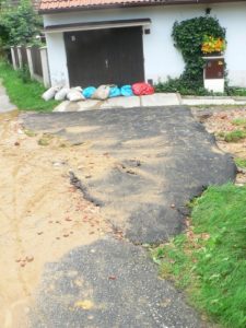
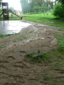
Municipalities try to deal with flood protection eliminating the impacts of flash floods, but it is more about implementing individual measures rather than a comprehensive conceptual approach to the issue of torrential rainfall. In this context it is possible to mention a good practice example of realization the risk reduction measure in form of the baulk in the administrative area of Kuřimany (see the section Good practice examples).
 To achieve the maximum elimination of the negative impacts of floods caused by torrential rainfall, especially on built-up areas of municipalities, a comprehensive assessment of the entire catchment area into which the rainfall will fall is necessary. This principle is the cornerstone of the “Study of applicability of risk reduction measures in spatial plans”, in which one of the pilot sites is the Strakonice site.
There are 2 so-called critical points in the locality Strakonice, which are places where the consequences of torrential rainfall enter the built-up areas of municipalities and start to cause property damage. The aim of the “Study of applicability of risk reduction measures in spatial plans” in the Strakonice locality is to propose such measures so that the so-called critical points disappear from the territory (ie the consequences of torrential rainfall would be fully captured before entering the built-up areas of municipalities) or at least the consequences of torrential rainfall in built-up areas would be minimized.
Based on the knowledge of local conditions (own research and consultations with the mayors of the municipality), risk reduction measures are proposed for the whole locality with the aim of mitigating the negative impact of torrential rainfall especially on built-up areas of municipalities. In particular, measures are proposed in this locality to eliminate erosive susceptible crops, to support conversion of arable land into grassland or to build up baulks or infiltration belts in the open countryside. There were also proposed several small retention reservoirs.
The proposed risk reduction measures are then confronted with the spatial planning documentation of individual municipalities in the locality Strakonice in the “Study of applicability of risk reduction measures in spatial plans”. From this confrontation it was concluded that none of the proposed measures is directly defined in the valid spatial planning documentation of individual municipality, however most of them do not interfere with any conceptual solution contained in spatial planning documentation of municipalities and could be placed (implemented) without change of spatial planning documentation. Only six measures conclude that they can influence the conception set in the spatial planning documentation. The reason for these “collisions” is always the placement of the draft protective measure in the built-up area defined by the spatial plan.
For the Strakonice locality it can 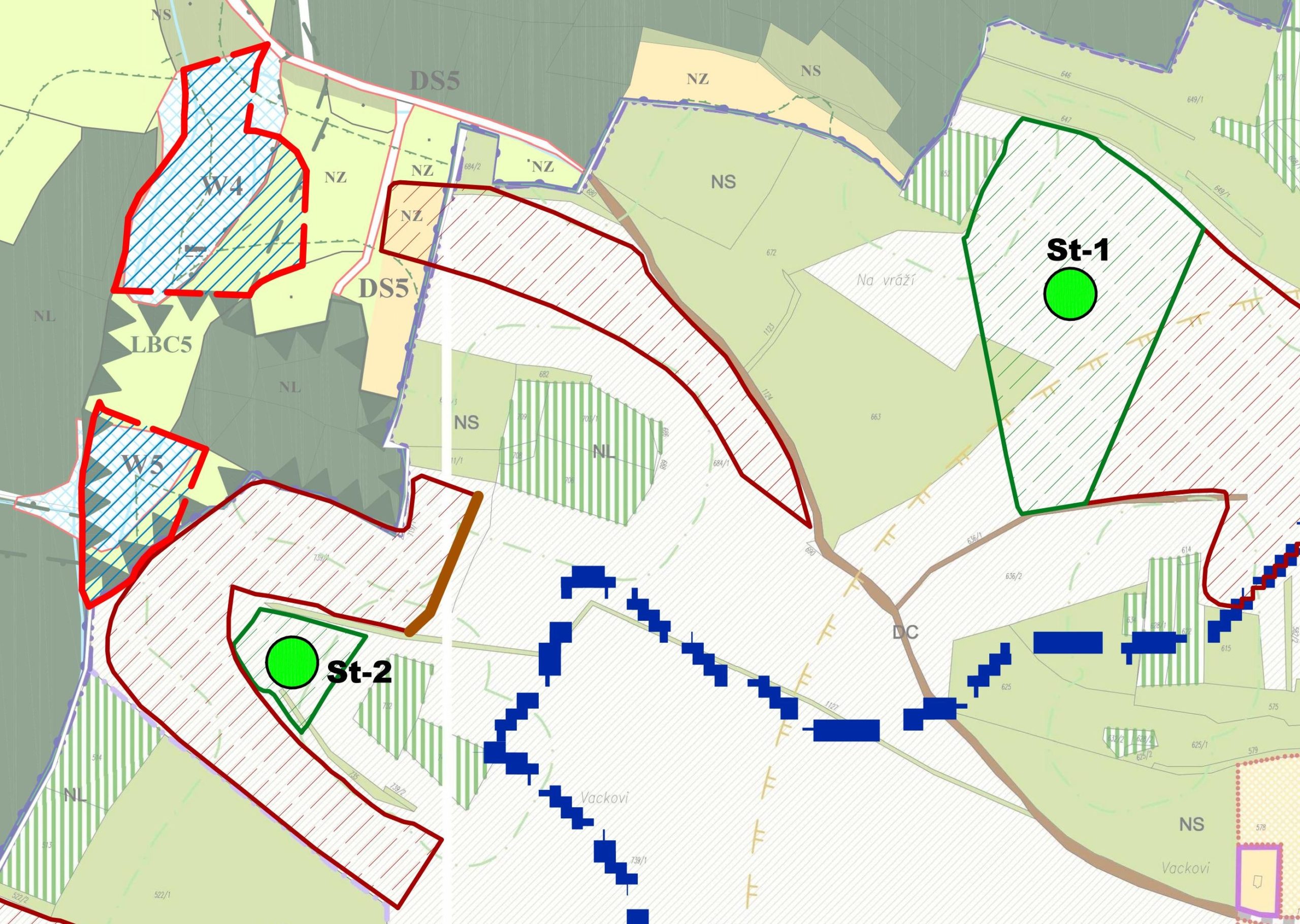 be stated that the proposed measures are suitable for the protection of the current state of the territory. However, for coordination with the proposals contained in the spatial plans of individual municipalities, it would be necessary to examine how to modify the proposed measure to take into account and protect the future assumed state of the territory. However, the “Study of applicability of risk reduction measures in spatial plans” in this locality did not go into this detail; nevertheless, a detailed comprehensive solution up to the form of individual changes in spatial plans can be seen at the Lipí site.
More detailed information about this locality can be found in the study (here) or it is possible to see specific realized measure from this locality “Building the baulk near the village Kuřimany” prepared as an example of good practice (here).

- All
- Assessment and mapping
- Risk communication
- Risk reduction measures

Building the baulk near the village Kuřimany
– Pilot area Strakonice
Read more in English [pdf, 444 KB]
Trainings on implementing the developed tools
– within the pilot regions in South Bohemia
Read more in English [pdf, 297 KB]
Critical points analysis
– for South Bohemia, CZ
Read more in English [pdf, 227 KB]
The locality is situated in South Bohemia, in the region Českobudějovicko.
This locality includes the territory of seven municipalities – Čakov, Habří, Hradce, Jankov, Kvítkovice, Lipí and Vrábče. The pilot site does not include the whole administrative territories of all the named municipalities, but only those that together belong to one compact small basin of the Dehtářský brook.
The area of territory: 26 km2
Pilot type – this location is agricultural and semi-urban. This location is mainly agricultural, in south-western part there is major predomination of forests (“Blanský les” highlands). There are a lot of breeding ponds in the northeastern part of this location.
Land form – northeast part of this location is plane or lightly hilly by contrast the south-eastern part-Blanský les – is hilly.
The locality is situated very close to the town České Budějovice. The town České Budějovice has a job potential and good transport accessibility. It is therefore specific for the locality that it includes municipalities, which have considerable potential for the development of built-up areas for housing.
Other specifics are:
- the area is situated in an important spring area at the beginning of the Dehtářský brook basin and includes a local pond system through which the brook flows,
- the western part of the site is considerably rugged and sloping.
 Municipalities in the locality have real experience with pluvial floods and they were struggling with the consequences of the heavy rain events. Heavy rain event at night 27th June – 28th June 2009 caused damages on real estate, infrastructure networks (sediment accumulation) and agricultural land (soil erosion). In case of a torrential rainfall, water flows into the village and causes damage to property in the built-up area. Torrential rainfall caused problems both in river canals and in concentrated surface runways. The damages caused by this heavy rain event was estimated at 180 000 CZK.
Municipalities try deal with flood protection eliminating the impacts of flash floods, but it is more about implementing individual measures rather than a comprehensive conceptual approach to the issue of torrential rainfall. In this context it is possible to mention a good practice example of realization the risk reduction measure in form of the culvert in the administrative area of Lipí (see the section Good practice examples).


To achieve the maximum elimination of the negative impacts of floods caused by torrential rainfall, especially on built-up areas of municipalities, a comprehensive assessment of the entire catchment area into which the rainfall will fall is necessary. This principle is the cornerstone of the “Study of applicability of risk reduction measures in spatial plans”, in which one of the pilot sites is the Lipí site. This site is the only one in the study elaborated until the form of changes in land use plans.
There is 1 so-called critical point in the locality Lipí, which is the place where the consequences of torrential rainfall enter the built-up areas of municipalities and start to cause property damage. The aim of the “Study of applicability of risk reduction measures in spatial plans” in the Lipí locality is to propose such measures so that the so-called critical point disappear from the territory (ie the consequences of torrential rainfall would be fully captured before entering the built-up areas of municipalities) or at least the consequences of torrential rainfall in built-up areas would be minimized.
Based on the knowledge of local conditions (own research and consultations with the mayors of the municipality), risk reducti on measures are proposed for the whole locality with the aim of mitigating the negative impact of torrential rainfall especially on built-up areas of municipalities. In particular, measures are proposed in this locality to eliminate erosive susceptible crops, to support conversion of arable land into grassland or to build up baulks or infiltration belts in the open countryside.
The proposed risk reduction measures are then confronted with the spatial planning documentation of individual municipalities in the locality Lipí in the “Study of applicability of risk reduction measures in spatial plans” and elaborated up to the form of changes of spatial plans of all municipalities. The content of the study in this locality is therefore own proposals for the change of spatial plans, which provide flood protection of municipalities and at the same time take into account the planned development of municipalities. Each proposed measure is shown in the draft of change of spatial plans as a specific area (or corridor) with a different use allowing essentially only the implementation of the risk reduction measure. For the implementation of some measures it is even necessary to change the defined proposal built-up areas intended for housing to areas for the implementation of flood protection.
For the Lipí site, it can be stated that the proposed risk reduction measures are solved in coordination with the planned development of all municipalities and should ensure the protection of newly built areas.
More detailed information about this locality can be found in the study (here) or it is possible to see specific realized measure from this locality “realization of the culvert in municipality Lipí” prepared as an example of good practice (here).


- All
- Assessment and mapping
- Risk communication
- Risk reduction measures
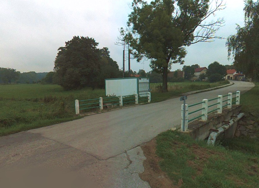
Realization of the culvert in the municipality of Lipí
– Pilot area Lipí
Read more in English [pdf, 474 KB]
Trainings on implementing the developed tools
– within the pilot regions in South Bohemia
Read more in English [pdf, 297 KB]
Critical points analysis
– for South Bohemia, CZ
Read more in English [pdf, 227 KB]