Tool ASSESSMENT and MAPPING

Practitioners' corner

Info

Overall, the systematic approach of public administrations to the issue of heavy rain flooding is relatively new in most European countries. However, a few countries already provide nationally or regionally agreed approaches, which are summarised in guidelines. In the lists below you will find already accepted practices in your region, which you can follow. If your region is not listed below, you may search the relevant administration websites of your country or region, or otherwise read the following sections to learn more about possible approaches.

Find answers to the following questions:

Are there approaches in my region, which I could use?

Overall, the systematic approach from public administrations to the topic of heavy rain floods is comparably new in most European countries. However, a few countries already provide nationally or regionally agreed approaches, which are fixed in guidelines. Please see below, if there are already agreed procedures for your regions, which you can follow. If you do not find your region in the lists below, you may search the relevant administration websites from your country or region, or otherwise read the following chapters to learn more about possible approaches.

If not: which methods for hazard assessment and mapping could help me?

For the assessment of heavy rain hazards, a large variety of methods is available and has already been applied in different European countries. This section briefly explains three common methods that are easily accessible to local administrations. Nevertheless, other existing methods can be found in the table of RAINMAN experiences below.

Get an overview of different methods:
Purpose, data and other requirements, mapping options, pros and cons

Empirical methods

If information from past flood events is available, an initial assessment can be made as to whether the region is likely to be frequently flooded or at risk of being flooded by heavy rain events.  Information from newspaper articles, photos, films, documentations and memories from different stakeholders like inhabitants, business people, emergency management, church or community and historians should be gathered to obtain all available inputs. Based on the information collected from specific events, the flooded areas can be mapped, and additional GIS analyses could provide further information such as water depths.

Empirical methods can be a first indication if no better data and only little money are available for a comprehensive risk assessment. Additionally, empirical methods can support the results of more sophisticated methods such as hydrodynamic simulations. The collection of observations of past events does not require special expert knowledge, but can be very time-consuming, may be fragmentary and therefore incorrect.

Flow path analyses

GIS terrain analyses can be used to identify depression lines of regions with moderate gradients. In such depression lines rain water is expected to accumulate and flow to the next river or lake. These analyses can be used to identify the main rainwater runoff paths, but no information can be obtained about flooded areas, water depths, flow velocities or the temporal development of flooding.

Terrain data in sufficient resolution (e.g. 1m*1m) provides the basis for this method, which can be improved by manually adding terrain break lines (e.g. streets, walls, culverts, transverse street slopes) which can significantly influence the flow paths. A GIS expert needs to apply the method, as he/she has to decide about several calculation parameters (filling depressions, …) and needs to deal with problems with the algorithm of steep slopes and flat areas.

It is helpful to involve people with knowledge about the local terrain and experience with heavy rain in order to check the plausibility of the calculation results.

With relatively little effort, flow path analyses deliver an initial indication, where problems with heavy rain surface water may occur in regions with moderate terrain slopes. Viable analysis results highly depend on the resolution of the digital terrain model, on manual additions of small structures and GIS calculation parameters. They provide no indication about water amounts, timing of flooding, water depths etc.

Hydrodynamic simulations

Hydrodynamic simulations are based on mathematical equations describing the flow of surface water and its infiltration into the ground. These analyses provide information about flooded areas, water depths, flow velocities and temporal development of the flooding.

Such hydrodynamic simulation models require the choice of a specific rain event, terrain data in high resolution, terrain surface and soil infiltration characteristics, which all together describe surface flow behavior of the rainwater on its way to the next river/lake. The manual inclusion of hydraulic relevant structures (walls, streets, culverts) into the terrain model is recommended. It is possible to also include the urban sewage system in such simulations, as it can play a significant role for the heavy rain scenario considered. Suitable software and a numerical simulation expert e.g. from a technical office with sufficient experience in heavy rain modelling is needed to properly account for all those factors.

It may be helpful to involve people with local terrain knowledge and heavy rain experience in order to check for the plausibility of the calculation results. Plausible results provide a good basis for communication with professional stakeholders and private persons, in order to illustrate spatial planning needs, legal requirements for buildings, emergency management planning and private measures.

Hydrodynamic analyses illustrate, where problems with heavy rain surface water may occur in regions with moderate to high terrain slopes. Additionally, the hazards for the heavy rain event can be quantified. Viable analysis results highly depend on DTM resolution, manual additions of small structures and adequacy of the used calculation parameters. Costs for hazard analysis are high, as expertise, special software and data are required.

If you want to learn more about the different types of methods, check out the ASSESSMENT and MAPPING experts’ corner.

PLEASE NOTE: all European Union member states have already published risk assessments and maps for river and torrential flooding. These fluvial risk assessments and maps are not to be mixed up with heavy rain flooding, as the characteristics are different:

  • In river flooding, water levels in the river bed increase and water floods the regions from below to above.
  • In heavy rain flooding, the rain water hitting the terrain surface cannot infiltrate into the soil or into sewage systems and thus runs down the slopes on the way to the next receiving river, lake or to the next terrain depression, which fills up. So the heavy rain flood hazard proceeds from above to below.

Let the RAINMAN experiences guide you...

In addition, the experiences of our RAINMAN experts can help you make the right choice:

“It is strongly recommended to document all damages and relating water levels with the help of photos, maps and other recordings after each event. A detailed damage documentation and report is a precondition for loss adjustment by insurance companies.”

Mapping of affected area and assessment of damages–Kirchsteigbachtal and Triebischtal, City of Meissen – Read more

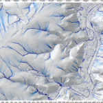
“Use the flow pathways analysis to get a fast and cost-effective impression of your potential flow patterns to identify potentially threatened areas and objects. You can also use the flow pathways analysis as a starting point for further in-depth analysis.”

Axel Sauer, Leibniz Institute of Ecological Urban and Regional Development, on flow pathways analysis – Read more 

“To know the whole dynamic during a heavy storm event a hydrological model and sewer model must be integrated in an urban flood model! Keep in mind that real storm events must be simulated, to verify such models with qualitative damage data from different sources!”

Stefan Leitner, Graz University of Technology, on integrated heavy rain risk maps for the City of Graz – Catchment Annabach – Read more

Several further methods and approaches to assessing and mapping of heavy rain risks were tested in RAINMAN. Browse through all OUR STORIES, if you want to find out more.

Why and how could I do risk assessment and mapping?

It is important to identify possibly affected persons and assets, the so-called risk receptors (e.g. toddlers in barrier-free kindergardens without a second level, hospital infrastructure in unprotected basement levels).

  • Identify receptors which might be damaged by heavy rain.
  • Assess how they would suffer damage (e.g. health impairments, destruction of assets, business interruptions, loss of infrastructure services, environmental pollution).
  • Assess the significance of the potential damage.

This can be done in a qualitative or quantitative way, see below for more information.

Qualitative risk assessment

Based on flood extent, water depths and flow velocities in the affected areas an initial selection of potential risk points can be made. Buildings with cellars might be flooded fast and pose a danger to life. Industrial installations using hazardous substances might pollute the environment and exposed electric transformer stations without flood precaution devices could break down easily. With this approach special risk hot spots can be identified for further risk mitigation measures.

This rather simple qualitative risk assessment based on joint reflection and careful consideration can be done by experts from the municipality, industrial installations and emergency management.

Quantitative risk assessment

In a quantitative risk assessment, damages to different kinds of assets like houses, cars, industrial installations or livestock are expressed in monetary values. Usually, damage curves describe the damage increasing e.g. with water depth. For potential heavy rain damage, such curves have not yet been established. Furthermore, monetary damage assessment is restricted to direct and tangible damages, and does not cover issues like health impacts, loss of production, or follow-up costs of traffic interruptions.

A quantitative risk assessment has to be implemented by risk experts for natural hazards, e.g. from scientific institutions or specialized technical offices.

Which stakeholders should be involved?

As a municipality, it is helpful to get several stakeholders on board of the heavy rain subject, as they are multipliers in the mitigation of risks from heavy rain:

  • Local spatial planners can help to keep hazardous areas free of buildings and infrastructure developments and thus prevent damages from valuable assets
  • Involve building permit officials: they can enforce constructions which ensure that heavy rain cannot enter the building and cause damages
  • Involve farmers with fields or livestock located above settlements and streets – the farmers can adapt their agricultural practices in order to prevent vulnerable buildings and infrastructures from damages.
  • Involve citizens and business people in order to make them aware of possible heavy rain risks, and encourage them to take self-protection measures
  • Involve emergency management and draft emergency management plans for vulnerable infrastructures and public assets
  • Involve a heavy rain risk expert who consults you on the issue (e.g. from your regional authority, from a technical office, or from chamber of agriculture, or chamber of commerce, or from a nationwide insurance company), and additionally one or two flood protection device traders who can illustrate the functions of self-protection devices
  • Moreover, all the above mentioned stakeholders may have local terrain knowledge and heavy rain experience that can support you in the verification of your calculation results, which is crucial regarding the acceptance of the hazard scenarios.

What's to be done next?

After the hazard and risk assessment information about possible flow paths, flooded areas, water depths, flow velocities and temporal development of the flooding from specific heavy rain scenarios are available. The mapped hazards and the resulting considerations regarding risk hot spots and sensitive infrastructure help to identify regions or installations where risk mitigation measures might help to avoid or reduce possible damages from existing or future receptors. Stakeholders are involved and ready to help acting, depending on their role.

Now the decision-making process for selecting measures can be started from different perspectives:

  • reducing the highest risks first,
  • implementing the measures with the highest risk reduction potential first,
  • implementing the measures with the best stakeholder acceptance first,
  • implementing the cheapest measures first,
  • implementing the measures with the best cost-benefit ratio first.

However, the prioritisation should be left to the municipalities and possible funding authorities, as a tailor-made solution for site-specific requirements is needed, taking into account all circumstances and stakeholders.

Riskreductiuonmeasures

The RAINMAN-Toolbox provides a comprehensive overview of possible measures: Browse through our CATALOGUE of 100 RISK REDUCTION MEASURES