Tool risk reduction measures

ADAPT SPATIAL PLANNING

What do you find here?

Info

Spatial planning has great potential for reducing the risks of heavy rain because of its interdisciplinary coordination function and the immanent consideration of various interests and concerns. This section supports local and regional planners with an overview of spatial planning options for heavy rain risk management combined with general recommendations for action. As the specific possibilities for implementing risk reduction measures in spatial planning depend strongly on the specific legal situation in the respective country, the tool also contains insights from different national perspectives.

What is SPATIAL PLANNING and how can it contribute to risk reduction?

Spatial planning has the task to coordinate competing land uses and conflicting objectives and to identify and promote multifunctional land use potentials. Also climate change, such as the increase in heavy rainfall events, has an impact on spatial structures and uses. Adaptation to climate change and hence heavy rain risk reduction is therefore a central issue in spatial planning.

By integrating goals for heavy rain risk reduction in spatial planning, heavy rain risks can be reduced at the local and regional level. Especially on the basis of hazard and risk maps, heavy rain risk reduction strategies can be designed with the help of spatial planning instruments.

What is important when considering heavy rain risks in spatial planning?

With current planning decisions, for example in the design of settlement areas, infrastructures, open and natural spaces, spatial planning is called upon to deal with natural risks of today and the foreseeable future. Only through early spatial and area-specific plans can risks be decreased and damage potentials reduced.

Recommendations for action:

Heavy rain risks are only one possible environmental risk.

Spatial and holistic concepts need to take various sectoral plannings and aspects of climate adaptation and protection into account. The reduction of heavy rain risks is only one planning criterion for the selection of water management oriented precautionary measures. In addition to heavy rain events, heat stress, the duration of droughts and the intensity of storms are expected to increase in the future. Ideally, measures are selected in such a way that synergies can be exploited and a measure is suitable for adapting to different impacts of climate change (for example green roofs support the retention of rainwater but also reduce heat).

On the other hand, conflicting objectives between different fields of action need to be balanced in planning decisions as early as possible.

Since heavy rain is a rather local event, and consequences depend very much on local characteristics, good local spatial planning can account best for suitable and effective heavy rain risk mitigation measures, e.g. through municipal zoning plans. Spatial planning at local and regional levels must be well coordinated to reduce heavy rain risk and meet the new challenges of climate adaptation.

Area-related planning measures to reduce the risk of heavy rain should be taken into account in new (urban) developments. Planning and design possibilities to safely steer surface runoff and avoid damages are more effective and easier to implement than adaptation measures in existing settlements. For example, it is easier to keep flood-prone areas free of e.g. buildings or to allow only flood-resistant buildings than to adapt existing settlement structures (reducing sealed surfaces, house protection, etc.).

Heavy rain risks can be taken into account in spatial planning by means of both formal and informal planning instruments. Formal, legally binding instruments create the necessary planning security. They must be developed in such a way that they can mitigate the effects of climate change through risk reduction and adaptation measures in the various fields of action. Informal approaches, on the other hand, tend to promote creative solutions and therefore offer a good opportunity to introduce new variants and alternatives.

Spatial planning determines the long-term use and function of spaces, and therefore has to take many future uncertainties into account, such as demographic changes, energy system transformation, and climate change. Today’s good practice spatial planning decisions may become unfavorable in the future, when unforeseeable climate change effects may significantly impact the quality of life. Therefore, more flexibility must be created for the changing environmental conditions, in order to reduce the vulnerability of regions and settlements and improve the quality of life through adaptive planning methods.

Consequently, planning processes and instruments should be kept flexible to establish a chain of successive strategic decisions with possibilities to develop binding effects rather than drawing up one comprehensive plan with final statements.

Climate change and its consequences, like increasing heavy rain risks, are an important issue and affect ecological as well as social and economic aspects of spatial development. Cities, settlements, roads, railways and waterways as well as supply and disposal infrastructures may be affected. Long-term spatial planning decisions are made for these land uses. The decisions made in the past regarding today’s land uses should be reviewed critically and reconsidered with regard to the necessary adaptations to climate change.

Planners must communicate risks as well as opportunities for the city or region to the stakeholders concerned. This should be done as early as possible, in order to create a common level of understanding, to coordinate different goals and to involve them in the planning processes. Appropriate cooperation and coordination mechanisms must be established for the implementation of risk reduction measures.

Given the likely magnitude of the adjustment challenges, it is important to work to safeguard resources and finances. Local authorities in particular need support. The proposed risk reduction measures are often not standard procedures, so that the necessary budget and the effect of the measure are often not known exactly. The results of cost-benefit analyses can therefore provide a good basis for the prioritisation of financing options.

Spatial planning strategies and measures for heavy rain risk reduction on the local planning level

Spatial planning strategies and some generic risk reduction measures in the field of spatial planning can be derived from the recommendations for action outlined above.

Adaptation of local planning activities

Current planning decisions should consider the risk of heavy rain, for example in the design of settlement areas, infrastructures, open and natural spaces. This includes the adjustments in built-up areas as well as the integration of these aspects in new developments.

  • Strategic documents
  • Establishing and considering of local and regional land-use planning
  • Intra-communal cooperation
  • Avoidance of building in hazard zones

Find out more in the CATALOGUE OF 100 RISK REDUCTION MEASURES.

There is a variety of more specific possibilities to adapt settlement areas and open spaces to the risks of heavy rain. A large part of these measures in the field can be divided into three categories.

Infiltration and avoidance of surface sealing

The construction of roads and buildings increases the degree of sealed surfaces in municipalities. Rainwater cannot infiltrate into the ground and runs off wildly and uncontrolled in the event of heavy rainfall. The more surfaces are sealed, the less rainwater can infiltrate into the ground and the higher the surface runoff. To improve infiltration capacities, new sealing of surfaces should be minimized, water-permeable materials and coverings should be used and paved surfaces should be unsealed.

  • Avoidance of building in hazard zones: Prevention by designation of specific grassland or protection zones in development or zoning plans
  • Absorbent pans/basins, filtration pans

Find out more in the CATALOGUE OF 100 RISK REDUCTION MEASURES.

Drain rainwater safely

Rainwater is usually drained via the underground sewer system up to a certain design limit. There are also possibilities to discharge rainwater in a controlled manner above ground, for example via specially constructed ditches and gutters or by using traffic areas for drainage. These can be designed e.g. as a separate rain water drainage system disconnected from the wastewater.

  • Drainage ditches; swales
  • Sustainable urban drainage systems for collecting, diverting and retaining surface runoff water
  • Multi-functional traffic and parking areas dedicated as thoroughfare for runoff or as temporary inundated retention

Find out more in the CATALOGUE OF 100 RISK REDUCTION MEASURES.

Retention and collection of rainwater

The water retention capacity of areas strongly influences the effects of a heavy rain event. To reduce surface runoff, different measures are suitable, either by temporally storage, improving evaporation or by drainage for infiltration at a later point. Such retention areas are to be kept free of buildings or infrstructure. At the same time, the storage of rainwater also enables its use for suitable private or industrial purposes.

  • Small retention reservoirs
  • Creation and maintenance of retention areas in urban areas
  • Increasing the retention capacity of existing channels and floodplains by restoration

Find out more in the CATALOGUE OF 100 RISK REDUCTION MEASURES.

Understand the background: spatial planning systems in different countries in the light of climate change

Specific options for action to reduce the risk of heavy rain through spatial planning measures are closely linked to the respective national legislation. Opportunities and limitations for the implementation of risk reduction measures highly depend on the national and/or area-specific planning system, its instruments and processes. Thus, it is essential to know and understand the respective national planning system, its opportunities and limitations. Find out more about spatial planning in different countries.

OUR STORIES

Implementation of the catalogue of measures in the local spatial planning of South Bohemia, Czech Republic

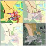
For the Czech Republic, a comprehensive study has been conducted that analyses the implementation of the catalogue of measures by spatial planning instruments in the pilot action of South Bohemia. Klick on the picture and explore the results. The guide provides more specific information about the risk reduction measures implementation in the pilot area of South Bohemia, as well as links and downloadable material with more detailed information, recommendations and best practice examples.

Integration of heavy rain risk management aspects in the Upper Elbe Valley/Eastern Ore Mountains Regional Plan, Germany

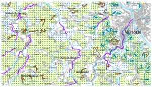
“Hardly any models exist in Germany for considering heavy rainfall events at regional level. In the region of Upper Elbe Valley/Eastern Ore Mountains a simplified risk assessment in the form of area prioritisation was carried out. Settlement areas, traffic routes, water bodies and regional priorities for river restoration downstream of run-off paths and steep slopes were taken into account. We can conclude that, when cooperating with specialist authorities and scientific institutions, regional planning can establish a framework for effective measures to reduce water erosion.” (Michael Holzweißig, Regional Planning Authority Upper Elbe Valley/Eastern Ore Mountains, DE)