Tool risk reduction measures

ADAPT SPATIAL PLANNING in the
CZECH REPUBLIC

What do you find here?

Info

Welcome to the Czech spatial planning website, where you can explore more about the risk reduction measures implementation in our pilot area. You find here links and downloadable material with more detailed information, recommendations and good practice examples from South Bohemia Region. There are 3 main sections, which will guide you from theoretical background about the spatial planning tools through the methodology on the implementation from the risk reduction measures to the municipal spatial plan to our study of applicability, where we show you a practical example in the pilot area Lipí u Českých Budějovic: verified in practice. Explore our GOOD TO KNOW section and find practical recommendations and advice which we collected during our negotiations and meetings with stakeholders of municipalities in our pilot areas.

Spatial planning tools

The diagram presents an overview of the spatial planning instruments in the Czech Republic and their mutual relations. An overview of the hierarchies given by the Building Act, binding and measure of detail, or the goal of the territory they address. The lower part of the diagram shows the possibilities of anchoring (overwriting) flood protection measures into individual groups of documents.

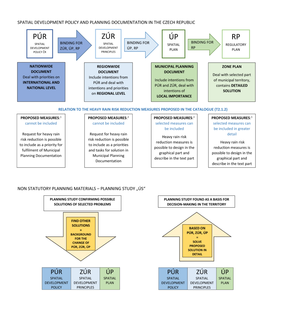
Spatial Development Policy of the Czech Republic is a conceptual document containing priorities of spatial planning of nationwide importance. In terms of flood protection, the task is to create conditions for preventive protection of the area against potential risks and natural disasters in the area (floods, erosion, landslides, drought) in order to minimize damage.

Read more: https://www.mmr.cz/en/ministerstvo/spatial-planning-and-building-rules

The Spatial Development Principles set out the basic requirements for the organization of the region and its effective use, defining areas and corridors for projects of over-local importance, i.e. important for the entire region.

Read more: https://geoportal.kraj-jihocesky.gov.cz/portal/uzemni-planovani/jihocesky-kraj/zasady-uzemniho-rozvoje-jihoceskeho-kraje

The Spatial plan addresses the whole territory of the municipality and defines the basic concept of its development. It divides the whole territory of the municipality into areas with different use and sets the conditions of use for them. The land use plan contains, among others, the concept of flood protection, it can propose concrete plans in the area of water management, erosion control. It may define selected projects as public works or public benefit measures.

The Regulatory plan addresses only a part of the territory of a region or municipality in which it sets detailed conditions. It delimits the individual plots and sets detailed conditions for their use (unlike the spatial plan, which solves the areas and not the detail of the plots). The regulatory plan may propose the specific location of flood control measures and the fundamental design of buildings and conditions in the endangered area.

The Planning study solves only part of the territory of a region or municipality, where it lays down detailed conditions. The scale is similar to a regulatory plan, but rather a substantial factual solution is in the drawings. It is not a spatial planning documentation, but only the background that can be used for decision-making in the territory.

You can find more detailed information in the download:

Heavy Rain Risk Reduction by Regional Planning Instrument [english, pdf, 4 MB]

spatial plan

From measures to spatial plan

The scheme describes which measures collected can be incorporated into the spatial planning documentation in the Czech Republic and what areas and corridors to use for these measures.

10
RISK REDUCTION MEASURES

to reduce the impact of heavy rain

0
RISK REDUCTION MEASURES

suitable for spatial planning documentation in CR

0
AREAS / CORRIDORS

in spatial planning documentation

You can find more detailed information here:

Successstory-clipped

Verified in practice

0
Pilot areas in South Bohemia
0
Municipalities included
0
New spatial plans

Study of the applicability of flood control measures into land use plan

I. Phase

In the first part, the study deals with the comparison of the proposed risk reduction measures proposed by the Research Institute of Water Management T. G. Masaryk with the valid spatial plans of individual municipalities. Its aim is to identify potential collision points between the proposal of risk reduction measures and the existing spatial planning documentation.

II. PHASE

In the second part, the study (in only one pilot area Lipí) deals with the proposal of risk reduction measures to eliminate damages after heavy rain event in coordination with the municipality’s interests expressed in the spatial planning documentation. It is therefore a proposal for changes to the spatial planning documentation of individual municipalities in the pilot area, which would ensure the required protection of the area against flood damage caused by pluvial flood and at the same time the development of the municipality.

You can find more detailed information in the documentations to download:

Study of the applicability of flood protection measures into spatial plans [english, zip, 80 MB]

Or check out OUR STORY FROM SOUTH BOHEMIA

Successstory-clipped

What is good to know?

To solve the problem, it is necessary to find the cause. In connection with the heavy rain event, it is essential to know the runoff conditions in the affected area. It is not the general truth that the cause is located in the administrative territory of the affected municipality. To eliminate the negative impacts of the rainfall is necessary the cooperation between cause and effect, i.e. between the municipality affected by the negative consequences and the municipalities from which the negative impacts come.

The most effective protection against the consequences of floods from torrential rainfall is the elimination of development areas located in vulnerable areas. Proper analysis of endangered areas can only be obtained through a comprehensive approach to ensuring flood protection and by analysing runoff conditions in one coherent river basin. Knowing the specific conditions can eliminate the design of development areas, whose protection will be uneconomical or even impossible.

The spatial plan will provide a comprehensive solution to flood protection as it is issued as a conceptual document for the entire administrative area of the municipality. The accurate location of the measures creates an assumption for their easier authorization. Due to their character, they can be described in the spatial plan as publicly beneficial buildings or measures. The system of subsidy titles is often conditioned by compliance of the measure with the spatial plan.

There are suitable risk reduction measures which, due to their character, cannot be anchored in the spatial plan because of its features defined by the Building Act. Agrotechnical measures can be an example, which impact on mitigating the negative consequences of torrential rainfall is very significant. Without implying these measures, it is not possible to achieve the desired effect, i.e. minimizing the negative consequences of floods caused by heavy rain.

The process of acquisition of the spatial plan, which is defined by the Building Act, does not include enough space for the necessary discussion of the proposed measures with the public, owners of affected lands, management entities etc. Sufficient communication and awareness of the need for a comprehensive flood protection solution leads to an understanding of the problem and a more responsive approach to the proposed solutions. For these reasons, it is necessary to pay increased attention to communication with affected entities beyond the framework of the Building Act.