

The pilot regions Zagreb and Umag together make up one out of seven pilot areas in the RAINMAN project testing the jointly developed methods and tools to reduce the risk of torrential rainfall. The pilots Zagreb and Umag have prepared a study with an external contractor as the main output. This study verifies the possibility of implementation of flood protection measures designed to eliminate damages caused by torrential rains (pluvial floods), especially in built-up areas in municipal spatial planning documentations in our pilot locations. At the same time, the study tests the possibility and appropriateness of using the jointly developed RAINMAN methods and tools.
The Zagreb pilot area covers app. 132 km² on the territory of the City of Zagreb, bordered by the watershed running along the highest ridges of Mt. Medvednica in the north, the Krapina river basin in the west, the Sava River in the south, and the Bukovački potok basin and Radnička St. in the east. The largest share is occupied by integrated and unconnected city areas and industrial and commercial facilities (app. 60 %) and areas covered by deciduous forest (Mt Medvednica slopes, app. 28 %). The remaining areas are areas with mostly agricultural purpose and a mosaic of agricultural areas (app. 12 %). The area has the characteristics of the moderate continental climate.
The specific feature of the selected pilot area is its terrain characteristics in terms of a sudden shift from the hilly to the lowland terrain, exactly in the highly urbanized zone, and the existing sewer system which is of a combined type.
Heavy rainfall poses a particular threat to urban environments, including the City of Zagreb. The situation is in some locations additionally aggravated due to topographic reasons. The concentration of stormwater from torrential streams from the Medvednica mountain massif also contributes to the intensity of floods. Material damage was recorded in the Zagreb area, not only in its immediate centre, but also in the wider city area, so far with no casualties. In addition to residential buildings lying in micro-depressions, significant damage can also be done to roads at points of grade separation (underpasses for cars and pedestrians, etc.).

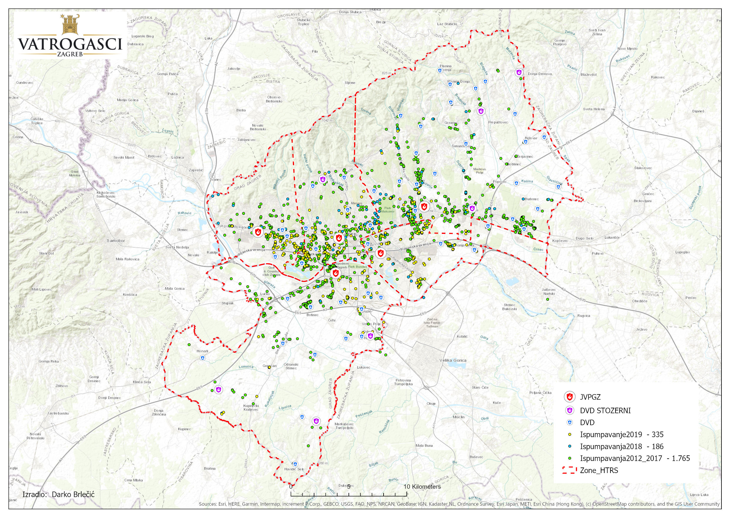
Locations of interventions related to the pumping out of water
Activities in the pilot area include involvement in assessment and mapping, risk reduction measures and risk awareness and communication. Special attention needs to be paid to the preparation of inputs as results largely depend on their accuracy; the development of a quality terrain model as well as the establishment of a hydraulic model. It is also important to select representative rainfall (design storm).
The first step in the implementation was an analysis of topographic and hydrological conditions of run-off in the project area. A terrain model has been developed and improved. Using GIS tools, the preferential flow routes have been defined as well as areas of depressions and grade separations that point to the potential critical points. A 2D flow was simulated using HEC-RAS tools. The results were then compared with the locations of interventions from the database of the Zagreb Fire Department.

Modelling phase I: Comparison of resulting depths and locations of interventions in the 2012-2019 period
The categorization of facilities based on their purpose gives information about the vulnerability of an area and consequently the guidelines for the application of appropriate measures.

Simulation results for the rain episode (2009)
As part of the project, a catalogue of risk reduction measures was prepared with a detailed overview of which measures are suitable for certain applications in which area. In addition to the measures, recommendations were also given about additional activities which can be implemented with the purpose of improving the model.

The basin of a watercourse called Umaški potok lies in the north-western part of Istria, on the territory of the towns of Umag and Buje, between the Dragonja river basin in the north and the Mirna river basin in the south. The Umaški potok basin has a surface area of app. 29 km2, whereas the hydrological basin is slightly bigger – app. 40 km2. The basin follows the direction in which the terrain spreads (SE-NW) and has two characteristic units in terms of relief and hydrogeology: the downstream part of the valley relief type and the upstream part with hills. The upstream part of the basin is mostly covered with meadows, pastures and forests. Due to dense vegetation, run-off is delayed despite steep terrain slopes. A few small settlements have been built here, mostly on hilltops and elevations. The major share of the valley part is tilled agricultural land which has a high water infiltration capacity, as the result of which surface run-off occurs only after long-lasting heavy rainfall. Urbanization is not marked; this region has mostly small settlements, with the exception of the town of Umag which is a marked tourist location. Surface flows can be followed in the intermittent flow of Umaški potok.
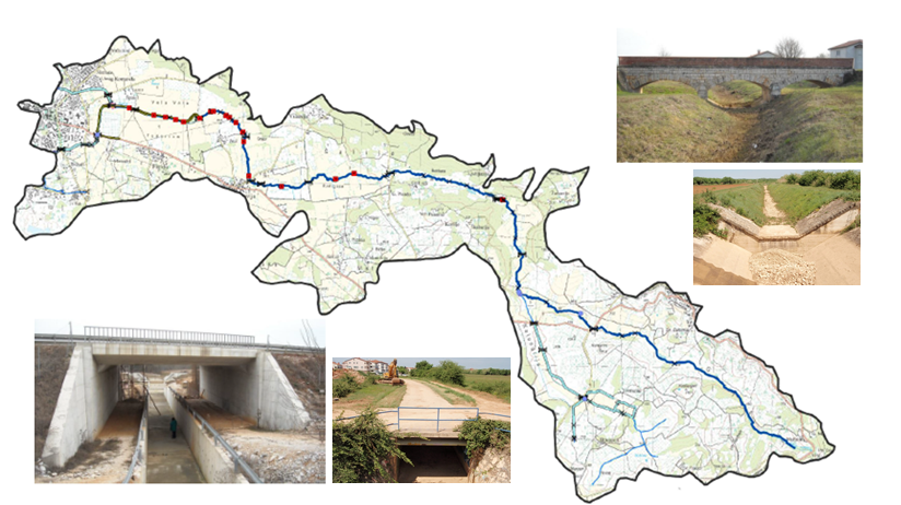
Hydraulic engineering facilities on the Umaški potok watercourse
Flood events occur very rarely, but with strongly felt consequences. The two key characteristics of this pilot area are the karst phenomena, which are to a significant extent present in the major part of Istria and cause a significantly more complex run-off system, and the presence of a complex impact of seawater level fluctuations on the run-off, both on a daily scale and on a scale of several years. In the context of climate change and a trend of rising seawater level, the problem of pluvial floods in areas like this carries additional weight.

Flooded areas (2019 flood)
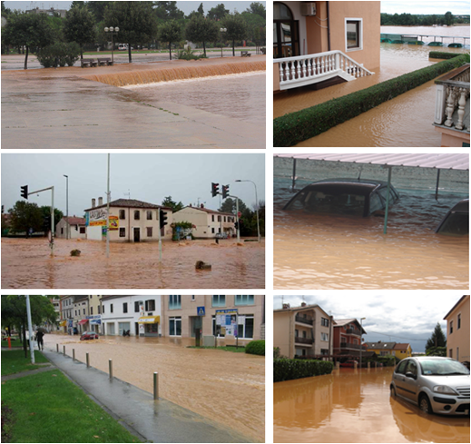
Flood consequences (2019)
The first and key step in risk analysis is the development of a flow model – from the development of an appropriate terrain model, the selection of the relevant rainy episodes to the comparison with the recorded interventions and definition of the assets exposed to the risk. The preparation was done using GIS tools, and the simulation of a 2D flow was done using the HEC-RAS software.

Digital elevation model of the Umaški potok basin

Scope of the Umaški potok basin pilot area
In order to achieve further improvements, for the coming period it is recommended to develop LiDAR surveys for the entire territory of Croatia and to conduct centralized, systematized and regular collection of data about the existing and planned infrastructure, facilities, (change of) land use, etc. in order to be up-to-date and available to the interested parties. Continued and systematized collection of flood reports from the public and voluntary fire brigades and other competent institutions is also recommended, with clearly defined data to be collected, followed by the creation and management of a database to develop tools for taking action timely.
Concerning model improvement in the field of meteorological data, detailed regionalization of short-lasting rainfall throughout Croatia is recommended. Furthermore, a correlation needs to be established between the measured meteorological indicators, topographic site conditions and the resulting flood events, serving as the basis for model calibration and risk analysis. Once established and verified, the model needs to be maintained, with each new project and the development and implementation of the spatial plans evaluated through the established model.
- All
- Assessment and mapping
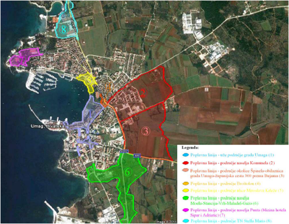
Heavy rain risk map for Umag river estuary, HR
Read more in EN [pdf; 678 KB]
Read more in HR [pdf; 211 KB]